A short trip can take longer than expected if it crosses a river, bridge, tunnel, or congested interchange.
Pittsburgh Traffic Explained: Bridges, Tunnels, Rush Hour & Commute Tips
A plain-English guide for residents, renters, homebuyers, visitors, and people relocating to Pittsburgh.
Traffic conditions, construction, transit schedules, fares, closures, and commute times can change. Use official tools like 511PA and Pittsburgh Regional Transit for real-time planning.
The short version
Many Pittsburgh commutes funnel through limited river crossings, tunnels, and hillside corridors.
Morning traffic often builds inbound toward job centers, while evening traffic often builds outbound from Downtown, Oakland, and other employment areas.
Roadwork, snow, rain, crashes, events, and hillside issues can change a normal commute quickly.
Pittsburgh Regional Transit offers bus, light rail, incline, trip planning, schedules, detours, park-and-ride, and real-time tools.
Before buying or leasing, check the route at the time of day you will actually travel.
Typical weekday commute traffic
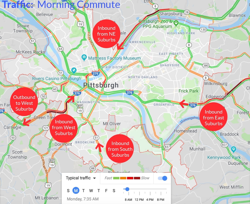
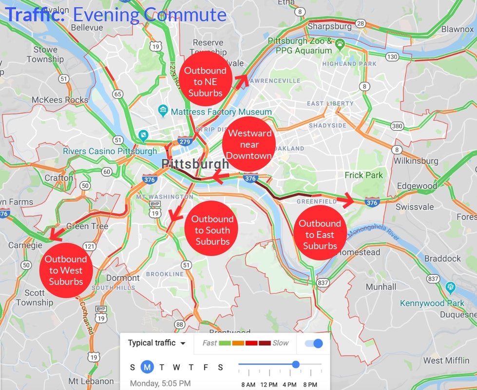
Pittsburgh rush hour is directional: mornings often stack traffic inbound toward Downtown, Oakland, and hospitals; evenings often stack outbound toward suburbs. The maps below show illustrative typical patterns—not live conditions.
Green = faster travel, red = slower on this illustrative map. Patterns vary by day, weather, and construction.
Illustrative typical traffic only—check 511PA before you leave.
North
Morning: Inbound on I-279 / Parkway North toward Downtown.
Evening: Outbound toward North Hills and Route 28 / NE corridors.
West / airport
Morning: Inbound on Parkway West through Fort Pitt Tunnel and bridge.
Evening: Outbound westbound—tunnel and bridge approaches often stack.
South
Morning: Inbound on Route 51 and connectors toward Liberty Tunnel and Downtown.
Evening: Outbound toward South Hills municipalities.
East
Morning: Inbound on Parkway East through Squirrel Hill toward Oakland.
Evening: Outbound toward eastern suburbs and parkway weave zones.
Why Pittsburgh traffic feels different
Pittsburgh is shaped by three rivers, steep hills, older neighborhood street patterns, bridges, tunnels, and limited cross-town routes. The fastest route on a map may not feel fast in real life. A commute can change dramatically based on whether it crosses a tunnel, bridge, river, major interchange, construction zone, event area, or hillside corridor.
Rivers create choke points
Three rivers split the region into basins. Many trips depend on a limited set of crossings rather than parallel grid streets.
Tunnels concentrate traffic
Tunnels compress lanes and merges. Small incidents or construction can ripple upstream quickly.
Hills limit direct routes
Grades and switchbacks mean alternates are often longer and steeper than they look on a map.
Older streets are not a simple grid
Narrow collectors, parking, buses, and tight corners can slow short urban segments.
Events can affect Downtown, North Shore, Oakland, and South Side
Games, concerts, and university activity can change curb rules, garage demand, and pedestrian volumes.
Weather and construction can quickly change travel times
Snow, rain, roadwork, and crashes can affect bridges, ramps, and hillside streets faster than a one-time map preview suggests.
How to think about Pittsburgh commutes
Use this as a planning frame before you treat a map preview as reality. This page does not publish travel times—conditions change too fast for that to be responsible.
A · Know the destination
Examples: Downtown, Oakland, Strip District, North Shore, South Side, East Liberty, Bakery Square, hospitals, universities, airport, suburban office parks.
B · Know the direction
Inbound, outbound, cross-town, river crossing, and tunnel commutes behave differently. A route that feels easy one way may feel harder the other.
C · Know the time of day
Morning, evening, lunch, school pickup, event traffic, and weekend sports or concerts can all change the same route.
D · Know the weak points
Bridges, tunnels, major interchanges, narrow neighborhood streets, and construction corridors are where delays often stack.
E · Test the route
Use mapping apps for typical travel patterns and 511PA for incidents, cameras, delays, and road conditions. This page does not publish live commute times.
Bridges and tunnels are the biggest thing newcomers underestimate
Many trips are less about raw miles than which river you cross, which tunnel you thread, and whether a small incident can starve you of good alternates. See the typical commute maps above, then focus on the crossings your route actually uses.
Fort Pitt Tunnel and Fort Pitt Bridge
Major gateway between Downtown and the Parkway West. Often sensitive during peak periods when approach lanes fill quickly—test inbound (morning) and outbound (evening) separately.
Squirrel Hill Tunnel (Parkway East)
Key eastern pinch point for Oakland, universities, and hospitals. Tunnel pacing and weave segments can define whether the trip feels smooth or stressful.
Liberty Tunnel and Route 51
Connects South Hills arteries toward Downtown and Oakland. Hillside alternates can absorb spillover when the tunnel or Grant Street approaches slow.
Fort Duquesne Bridge and I-279
North Shore, Downtown, and North Hills threads converge here. Stadium and arena nights can change merges and garage demand quickly.
Destination matters as much as where you live
Because Pittsburgh compresses trips onto crossings and tight urban segments, sometimes the job site (or clinic, campus, stadium night, hospitality shift) defines the commute more than neighborhood labels do.
Downtown (Golden Triangle)
What changes the commute: garages, pickups, scooters, pedestrians, valets, hotel loading, reroutes for events.
Oakland and Uptown
What changes the commute: universities and hospitals generating midday and shift peaks that ignore a neat rush-hour story.
South Side and Station Square rotations
What changes the commute: pedestrians, pickups, scooters, hillside streets feeding bridges, nighttime economy overlays.
Strip District
What changes the commute: curb cuts, unloading, shopper traffic, short segments that clog when everyone tries the same path.
Lawrenceville and Bloomfield
What changes the commute: narrower collectors, frequent signals, scooters, pickups, hillside alternates feeding bridge ramps.
North Shore
What changes the commute: stadium and arena overlays, garages, pedestrians, pickups, scooters, and police-directed patterns on big event nights.
Regional job centers beyond the urban core
What changes the commute: industrial parks and distribution footprints that pulse on shifts different from Downtown white-collar patterns.
Public transit can change the commute equation
PRT can be excellent along certain corridors—and the wrong assumption for trips that depend on steep walks, midday headway gaps, or transfers that fall apart in weather. Decide based on rehearsal: walk the last mile twice, verify stops and shelters on hot and cold days, and read agency updates anytime detours multiply surface conflicts with cars.
Corridor fit beats city-wide generalizations
A route can be great on Tuesdays and brittle on Fridays if events, closures, reroutes, or shift changes saturate the same segment you rely on.
First and last mile is topography
Hills and stairs matter. Elevator outages at stations matter. Sidewalk detours matter. Pretend transit starts at your door, not at the stop pin.
Reroutes redraw the roadway mix
Buses forced onto detours behave like unusually wide cars—your drive can change even if you never ride transit.
Park-and-ride is conditional
Lots fill, snow piles narrow aisles, and schedules change seasonally.
TrueTime and schedules are discipline
Habituating yourself to checking live arrivals and headline service changes prevents “almost made it” misses.
Parking still shapes many “transit commutes”
Drop-offs, pickups, kiss-and-ride confusion, garage swaps, and scooters that link you to a stop are part of the commute—budget them.
Parking is part of the commute
Parking often decides whether a commute is workable for real life—not just whether a freeway segment looks green on a map.
- Garage entrances and payment readers can bottleneck even after a smooth bridge leg.
- Residential permit strips and loading bans change hourly—overnight towing or tickets can punish “five-minute” stops.
- Event overlays can reorder garage pricing or close preferred exits without announcing it loudly enough for non-locals.
- Steep ramps, tight turns, and older structures punish rush-hour merges—assume time for walking the last blocks when it is safer.
- Snow piles and plow ridges narrow curbs overnight; parallel parking lanes shrink unexpectedly on steep blocks.
- Visitor passes, placards, and guest-house rules vary by landlord and HOA.
- Operators and garages change pricing and protocols—bookmark official parking resources alongside roadway tools.
Weather and hills matter more than many newcomers expect
Freeze–thaw cycles, hillside shade, cobbles, bricks, drains clogged with leaves, and morning glare across river decks change stopping distance faster than commuters notice on a radar map. Winter maintenance priority routes can differ from the cute side street beside your Airbnb.
Pothole patching can move lane striping week to week. Pedestrians, scooters, glare, nighttime deliveries, and slippery cobbles compete for driver attention—even when arterial sensors look “okay.” Build buffer for human reaction times on grades, not posted limits alone.
For forecasts and hazardous weather outlooks affecting travel decisions, bookmark the nearest National Weather Service office you trust and skim it before unfamiliar night drives.
Why construction and repairs can feel complicated
Multiple agencies often share responsibility for travel pain along what maps label as “one corridor.” Freeway postings can interact with Allegheny County detours and city resurfacing programs—all while Pittsburgh Regional Transit reroutes tug buses onto the side streets commuters hoped were secret alternates.
Bookmark the authoritative sources summarized below—they match the official links curated at the bottom of this page.
- Road closures and statewide traveler signals: 511PA
- How statewide tools fit PennDOT communications: 511 PA — PennDOT media resources
- Regional PennDOT office: PennDOT District 11
- City-framed mobility work: City — Mobility & Infrastructure
- Local roadway safety pacing context: City — Traffic calming
- County roadway programs: Allegheny County — Roads
- PRT + trip planning anchors: PRT home, Plan your trip, All schedules, Service updates, TrueTime, Park-and-Ride
- Airport-heavy days: Fly Pittsburgh
- Downtown garage-oriented commutes: Pittsburgh Parking Authority
Pittsburgh Commute Reality Checker
This rule-based checklist highlights what rehearsal usually surfaces. It intentionally avoids travel times—conditions change mile by mile.
Planning checklist tailored to your inputs
Reminder: incidents, weather, closures, reroutes, and events override any static guidance—trust rehearsal plus dashboards.
How to test a Pittsburgh commute before choosing where to live
Use this rehearsal list with 511PA; it still beats guessing from a touring-day snapshot.
- Search the route at the exact time you expect to travel.
- Test both morning and evening directions.
- Check whether the route depends on a tunnel, bridge, or major interchange.
- Look up parking at the destination.
- Check transit alternatives.
- Check school or daycare drop-off and pickup timing if relevant.
- Watch for major event locations.
- Compare weekday and weekend travel.
- Add winter and weather buffer.
- Try the route in person before buying or signing a long lease when possible.
City vs suburb commute planning
Swipe sideways on phones to reveal the suburb column.
| Topic | City living | Suburban living |
|---|---|---|
| Distance to job centers | Often closer to hospitals, universities, Downtown, restaurants, and cultural districts | May require highway, tunnel, bridge, or parkway travel depending on location |
| Parking | Can be tighter and may require permits, garages, or off-street parking | More off-street parking, but destination parking still matters |
| Transit | More walk, bus, bike, and short-trip options in many neighborhoods | Park-and-ride, bus, or light rail may work well in certain corridors |
| Commute predictability | Shorter distance but more local congestion, parking, and events | Longer distance and more exposure to highway incidents or tunnel/bridge bottlenecks |
| Best next step | Check parking, walkability, bus routes, and destination-side congestion | Test the exact route during rush hour and compare transit/park-and-ride options |
Traffic tips for people moving to Pittsburgh
Practical tips for people comparing neighborhoods, suburbs, and commute tradeoffs.
Do not judge the commute by mileage alone
Rivers, tunnels, hills, and parking can matter as much as distance on a map.
If your commute crosses a river or tunnel, test it carefully
Limited crossings can make one incident feel much bigger than the mileage suggests.
Oakland and Downtown parking can be as important as drive time
Garages, permits, and event traffic can change the real commute experience.
East End neighborhoods can be convenient—but still require route testing
Hospitals, universities, and tech jobs are nearby for many East End routes, but local streets still need rehearsal.
South Hills commutes may benefit from light rail
Depending on the exact location, the “T” can be a strong option for some Downtown and North Shore trips.
North Shore and Downtown event traffic can change normal patterns
Games and concerts can affect bridges, garages, and curb rules on event nights.
Airport corridor commutes can vary by tunnel and parkway conditions
Check 511PA and allow buffer on flight days.
Flexible furnished housing can give you time to learn the city
A furnished doSh home can help you test commutes before choosing a permanent neighborhood.
Pittsburgh traffic questions
Is Pittsburgh traffic bad?
Pittsburgh traffic is manageable for many people, but it can be frustrating because distance does not tell the whole story. Bridges, tunnels, hills, rivers, construction, weather, parking, and event traffic can make short trips take longer than expected.
Why do bridges and tunnels matter so much in Pittsburgh?
Pittsburgh’s rivers and hills force many routes through limited crossings and tunnels. When traffic, construction, weather, or a crash affects one of those routes, delays can build quickly.
What is the best way to check current Pittsburgh traffic?
Use 511PA for current road conditions, incidents, delays, traffic cameras, weather restrictions, and route alerts. For transit, use Pittsburgh Regional Transit’s trip planning, TrueTime, schedules, and detour tools.
Is public transit useful in Pittsburgh?
It can be, depending on where you live and where you are going. Bus, light rail, incline, park-and-ride, and real-time tools can make transit a strong option for some Downtown, Oakland, North Shore, South Hills, and East End trips.
What should I check before choosing a neighborhood?
Test the commute at the actual time of day you will travel, check whether it involves a bridge or tunnel, compare parking options, look at transit alternatives, and consider school or daycare timing if relevant.
Are Pittsburgh commute times the same in both directions?
Not always. Morning and evening traffic can behave differently because routes are directional. A route that feels easy inbound may feel harder outbound, or vice versa.
Does weather affect Pittsburgh traffic?
Yes. Snow, ice, heavy rain, hills, bridges, ramps, and construction zones can all affect travel. It is smart to check current conditions before driving in bad weather.
Is living closer to work worth it in Pittsburgh?
Often, yes. Because rivers, tunnels, bridges, parking, and hills can matter as much as mileage, living closer to work, school, hospitals, or daily needs can improve quality of life.
Official sources and helpful links
More Pittsburgh relocation resources
Moving to Pittsburgh and still figuring out commute, neighborhoods, and housing?
If you are relocating, comparing neighborhoods, or waiting to decide where to live long term, a furnished doSh home can give you time to settle in before making a permanent decision.
Furnished Housing Solutions |
Support
|
Info |
Relocating to Pittsburgh |
© COPYRIGHT 2015. ALL RIGHTS RESERVED.
|